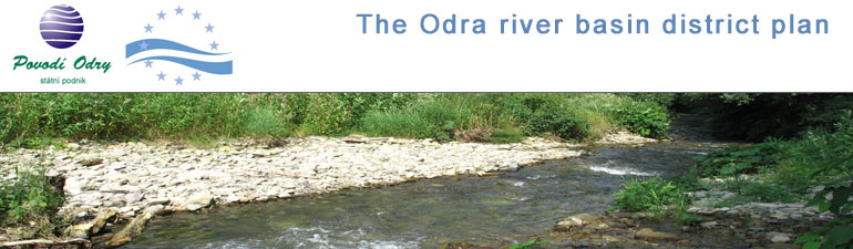
International river basin district of the Odra
The Odra river basin district represents the upper stretches of the international Odra river basin district (flowing into the Baltic Sea), where the main river in this river basin district springs - the Odra river.
The area of the International river basin district of the Odra:
| Czech | Poland | German | Total |
|---|---|---|---|
| km2 | |||
| 7 217 | 106 057 | 5 587 | 118 861 |
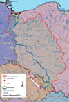
Odra river basin district
The area covers 6,252 km2 and it is the smallest of
eight river basin districts in the Czech Republic.
The Odra river basin district in the Czech Republic has a prolonged
shape in the NW-SE directions. In the south-west, it borders
along the watershed of the Baltic and the Black Sea on the
area of the Moravia river basin and the Váh river basin. In
the north-east it borders on the Polish side of the upper
Odra river basin district and the Visla river basin and in the Polish
Republic, it flows into the confluence of the Odra and the
Olše in Bohumín. Some parts of the Odra river basin district flow
by gravity into the Odra beyond the closing profile Bohumín
in the Polish Republic, i.e. the Osoblaha, Bělá and Vidnávka
rivers.
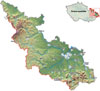 Despite its relatively small size, the Odra river basin district
has great differences in the altitude. This is due to its
position between the rock massif of the Hrubý Jeseník and
the Beskydy mountains and its opening towards the north to
the Silesian lowland. The Odra springs in the Oderské vrše
at an altitude of 634 m a.s.l. and leaves the republic at an
approx. height of 190 m a.s.l. In the south-western
watershed which is at the same time the main European
watershed of the Danube and the Odra, the altitude in the
region of the Hrubý Jeseník reaches a maximum of 1,492 m
a.s.l. (Praděd) and in the Beskydy mountains a max. of
1,323 m a.s.l. (Lysá hora). The highest vertical distance
is this almost 1,300 m. Generally, it is an area with a
great relief energy, as, for example, the difference in the
altitudes in the Ostravice river basin between the highest
(Lysá hora 1,323 m a.s.l.) and the lowest point (flows into
the Odra) of this river basin measuring 35 km as the crow
flies a total of 1,125 m.
Despite its relatively small size, the Odra river basin district
has great differences in the altitude. This is due to its
position between the rock massif of the Hrubý Jeseník and
the Beskydy mountains and its opening towards the north to
the Silesian lowland. The Odra springs in the Oderské vrše
at an altitude of 634 m a.s.l. and leaves the republic at an
approx. height of 190 m a.s.l. In the south-western
watershed which is at the same time the main European
watershed of the Danube and the Odra, the altitude in the
region of the Hrubý Jeseník reaches a maximum of 1,492 m
a.s.l. (Praděd) and in the Beskydy mountains a max. of
1,323 m a.s.l. (Lysá hora). The highest vertical distance
is this almost 1,300 m. Generally, it is an area with a
great relief energy, as, for example, the difference in the
altitudes in the Ostravice river basin between the highest
(Lysá hora 1,323 m a.s.l.) and the lowest point (flows into
the Odra) of this river basin measuring 35 km as the crow
flies a total of 1,125 m.
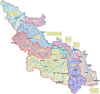 The upper Odra river basin district consists mainly of smaller
streams and it is located at the border of two important
geographical units -the Czech Highlands and the Western
Carpathians. The Odra and its main tributaries, the left-side
Opava and Moravice and the right-side Ostravice and Olše,
create the skeleton of the hydrographical network flowing
into the Ostrava basin. The Odra stream in the Moravská brána
creates the axis of boundary between the Czech Highlands and
the Carpathians. The most important stream in the river
network is the Odra, springing in the Oderské Vrše. From
here it flows in the south-eastern direction and after
approx. 55 km its route turns perpendicularly at the
entrance to the Moravská Brána. From here it flows to the
north-east to the Ostravská pánev and the state border
with the Polish Republic. It creates approx. 8 km of the
state border and it leaves the CR at Kopytov downstream the
confluence with the Olše (district of Bohumín) at an
altitude of 190 m a.s.l. The length of the Odra itself is
132.3 km in the Czech Republic, the length across the Polish
Republic to the estuary into the Baltic Sea is 734.3 km.
The upper Odra river basin district consists mainly of smaller
streams and it is located at the border of two important
geographical units -the Czech Highlands and the Western
Carpathians. The Odra and its main tributaries, the left-side
Opava and Moravice and the right-side Ostravice and Olše,
create the skeleton of the hydrographical network flowing
into the Ostrava basin. The Odra stream in the Moravská brána
creates the axis of boundary between the Czech Highlands and
the Carpathians. The most important stream in the river
network is the Odra, springing in the Oderské Vrše. From
here it flows in the south-eastern direction and after
approx. 55 km its route turns perpendicularly at the
entrance to the Moravská Brána. From here it flows to the
north-east to the Ostravská pánev and the state border
with the Polish Republic. It creates approx. 8 km of the
state border and it leaves the CR at Kopytov downstream the
confluence with the Olše (district of Bohumín) at an
altitude of 190 m a.s.l. The length of the Odra itself is
132.3 km in the Czech Republic, the length across the Polish
Republic to the estuary into the Baltic Sea is 734.3 km.